Realistic runoff estimates are crucial for accurate design of storm water drainage systems, particularly in developing urban catchments which are prone to overland flow and street inundation following extreme rain storms. Khartoum, capital of Sudan, as many cities of the developing countries, lacks proper storm water drainage system. Local government is however, spending efforts to plan and design several storm drains in attempt to mitigate the problem of urban flooding during rainy season. This paper aims to estimate surface runoff in order to design a proposed storm drain in west central Khartoum. Long-term rainfall intensity data was analyzed in order to produce Intensity-Duration-Frequency curves. The Rational model was used for runoff estimation and Manning formula for storm drain design. Geographical information system was used to visualize surface and topographic data and to obtain catchment characteristics. The storm drain was sub-divided into five sectors and the maximum calculated peak runoff was 3.17m3/s based on rainfall intensity of 10-year return period. The proposed drain design was rectangular in shape with a maximum cross sectional area equal to 3.3m2 (1.65 x 2m). Challenges to planning sustainable stormwater structures in Khartoum City were attributed to climate variability, urban development and change in surface conditions.
Keywords
Rational Model
Runoff coefficient
Manning formula
GIS
Climate variability
Khartoum
INTRODUCTION
Runoff is one important component of water cycle, it occurs when excess precipitation water flow on the earth surface after surface (ponding, evaporation) and subsurface (infiltration) losses are fulfilled. It is a process highly controlled by rainfall behavior and land surface condition. Runoff start by short distance over ground sheet flow that accumulates in galleys and eventually flows through proper streams or channels. Estimation of surface runoff is a key element for many environmental studies such as water resources management, flood control and soil erosion [1]. On the other hand, accurate amount of surface runoff is required by hydrologists and engineers for planning and designing safe hydraulic structures [2] because in urban areas, unmanaged stormwater runoff causes flooding and pollution [3-4]. Changing natural land surface due to urbanization creates more impervious areas leading to decreased infiltration and increased runoff [4]. Therefore, stormwater drainage systems have been installed in cities and urban centers since early civilizations [5]. Their main objective was basically, to quickly remove excess rainwater from streets of urban areas to receiving natural systems without any other considerations like resources management and pollution control [6-7]. Such environmental issues are taken care off by other drainage systems such as Water Sensitive Urban Design (WSUD) and Best Management Practices (BMPs) [4]. The concept of Rainwater Harvesting (RWH) from urban catchments has been tested in Khartoum City by Mahmoud et al. [8]. Generally, efficient runoff management systems are required in urban centers around the world, particularly in developing countries [9].
Khartoum City, the administrative capital of Sudan, is located within the flood plain of the River Nile at the confluence of the White Nile and the Blue Nile Rivers. It comprises the largest urban center in Sudan but lacks proper stormwater drainage system [10] except for a limited zone comprises the commercial and business district area of Khartoum City center [11]. In addition to some scattered open-channel earth drains which suffer from mismanagement and clogging with garbage and dirt. It is very likely to see roads, basements and open spaces inundated shortly following a rainy storm. Local authorities spend huge efforts and high cost to prepare for rainy season every year facing rapidly changing urban environment. With average annual precipitation exceeding 130mm over the last three decades [11] and the increasing probability of occurrence of flood generating rainstorms in central Sudan [11-12], Khartoum is expected to continue enduring road inundation, infrastructure losses and public life disturbance every rainy season. Therefore, stormwater drainage system is badly needed in order to collect and transfer runoff water. The objective of a stormwater drain is to ensure safe conveyance of runoff water from roadway surfaces towards a suitable receiving body, usually a natural water body [13], to protect private and public buildings during flood events and to assist in management of water resources [14,5]. Storm drains are usually gravity based open or closed channels or large pipes. This contribution demonstrates a case study of designing an east-west 6.3km long storm drain in central Khartoum. It is one of several storm drains proposed by the Khartoum State government in order to alleviate inundation of roads and built-up area during rainy season. No particular attempts for stormwater resource management and pollution control are made in Khartoum so far. Specific objectives are to estimate surface runoff and to design stormwater drain capable of carrying water from the surroundings and delivering it to White Nile River. Rainfall intensity analysis and the Rational model shall be employed to estimate the peak runoff resulting from prescribed rainstorm events, while Manning formula is used for the hydraulic designof the storm drain. Surface and topographic data are manipulated in Geographical Information System (GIS).
MATERIALS AND METHODS
Materials
The following data were used in this study: a 100-year rainfall intensity data for Khartoum station from the Sudan Meteorological Authority, SRTM 1 Arc-Second Global elevation void filled data at a resolution of 1 arc-second (30 meters) of the Shuttle Radar Topography Mission and Landsat ETM+ (30m) image of Khartoum from the official USGS websiteEarthExplorer in addition to the Geological map of Khartoum (1:250,000, 1993), the Land cover map of Khartoum State [15].
Methods
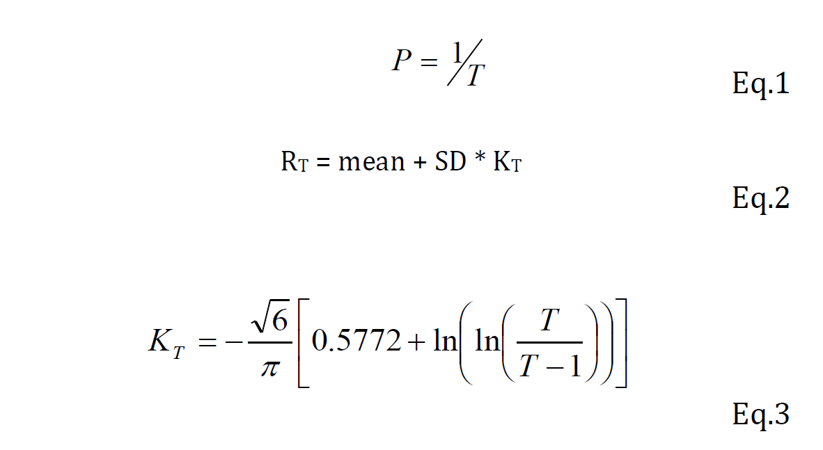
Frequency Analysis of Rainfall: Rainfall intensity expressed in (mm/h) represents the rate of rainfall or the amount of rainfall during a certain period of time (duration). The probability (p) of a given rainfall intensity is reached or exceeded, resamples the frequency and could be expressed as the reciprocal of return period (T), Eq.1. In order to obtain the intensity-duration-frequency curves (IDF curves), Extreme value type I distribution (Gumbel function) of rainfall intensity was assumed. In fact, Gumbel distribution function [16] has been acceptedby different authors [11,17] to represent extreme rainfalls in Khartoum region. Therefore, average values and standard deviations of rainfall intensity for Khartoum station were calculated and analysis were performed following equations (Eq.1, 2 and 3) from Wilson [18] in a similar way as explained by Babiker and Mohamed [17] who have used the same data set of Khartoum Meteorological station:
Where: RT = Rainfall intensities for T return periods (mm/h),T = Return period, p = Probability, KT = Extreme value type I distribution frequency factor, SD = Standard Deviation and N = Number of data
Peak Runoff Estimation
The widely used Rational model [19] is applied in order to estimate the over ground runoff. It has been successfully used for estimating design discharge from small catchments [9,20,17]. The Rational model is a linear relationship that expresses the dependency of peak runoff (discharge) on drainage area, rainfall intensity for a specific period of time (time of concentration of watershed) and a runoff coefficient depending on land surface condition (Eq. 4).
Where: Q = Peak rate of runoff (m3/s), C = Dimensionless runoff coefficient function of the watershed cover, I = Rainfall intensity for the duration equal to the time of concentration (mm/h), A = Drainage area (km2), Ku = Unit convertor factor (0. 278 for metric unit).
The Rational model is suitable for small catchment size (maximum of 25 km2 for urban and 3-10 km2 for rural areas) [21]. Small catchment size ensures the uniformity of rainfall intensity and duration over the study area and the storm duration shall reach or exceed the time of concentration of watershed. The runoff coefficient “C” is one of the challenging issues in the application of Rational model because it represents an integration of many different catchment’s characteristics. It is used to define the fraction of catchment area actually contributing to peak runoff based on surface conditions. Runoff coefficients recommended by the American Society of Civil Engineers and Water Pollution Control Federation [22] were used (Table 1). In this study, the ”C” value was varied between 0.2 and 0.5 according to land cover type in the different storm drain sectors as shall be explained later.
Table 1: Runoff Coefficients of Rational Model [22]
Type of catchment
Runoff coefficient
Business
Downtown
0.70-0.95
Neighborhood
0.50-0.70
Residential
Single-family
0.30-0.50
Multi-units, detached
0.40-0.60
Multi-units, attached
0.60-0.75
Suburban
0.25-0.40
Apartment
0.50-0.70
Industrial
Light
0.50-0.80
Heavy
0.60-0.90
Parks, Cemeteries
0.10-0.25
Playgrounds
0.20-0.35
Railroad yard
0.20-0.35
Unimproved
0.10-0.30
Time of concentration is defined as the time required for storm water to flow from the most remote point of the catchment to its outlet [23]. The time of concentration of 20 minutes was proposed by AUS-SPEC [14] for urban areas. Here, it is calculated according to Eq.5 [13] assuming average over ground velocity equals 0.4m/s.
Where: Tc = Time of concentration (min), L = Longest flow path (m), V = Average velocity (m/s) depending on mean surface slope.
Storm Drain Design
The well-known and commonly used Manning’s equation[24] (Eq.6, 7) was applied in order to design the storm drain. Taking into consideration the proposed material (non-metal brickwork) of the drain, the Manning’s constant (n) was taken to be 0.015.
Where: n = Manning roughness coefficient, A = Flow cross sectional area (m2), p = Wetted parameter (m), S = Longitudinal slope (m/m), V = Flow velocity (m/s), Q = Discharge (m3/s).
Land surface and topographic data were stored and manipulated in GIS environment. ILWIS 3.6 was used to analyze the digital elevation data (DEM) in order to extract various topographic and hydrologic characteristics of the study area. Catchment area contributing to different drain sectors were delineated and flow paths were identified. GIS was also used to visualize satellite imagery, to identify land cover and prepare different thematic maps. Field survey was conducted to confirm or modify land cover described from satellite imagery and to examine the storm drain route and surroundings.
The Study Area
The study area is located in the west central part of Khartoum City, which is located south of the confluence of the White and Blue Nile Rivers. Together with Khartoum North and Omdurman, they form the Greater Khartoum, the capital of Sudan (Figure 1).
Figure 1: Location Map of Study Area
Khartoum area is part of the flat flood plain of central Sudan. The western Khartoum area particularly is found on the White Nile flood plain making a 3km wide strips on both banks. Geologically, Khartoum region consists of basement complex overlained unconformably by Nubian Sandstone Formation that is overlained by Gezira formation and Quaternary deposits including Nile alluvium and windblown sands, the Nubian Sandstone is intruded by Tertiary basalts [25-26]. The study area represents part of the NW-SE trending Nile-Sahara Nubian basin comprised mainly (70% of its area) of groundwater rich Nubian sandstone aquifer [27]. Being recharged from the River Nile system, the Nubian aquifer supplies groundwater that is good in quality and quantity [26]. The elevation of the area between the two Niles ranges from 360 m.a.s.l along the White Nile River plain to about 400 m.a.s.l (Figure. 2).
Figure 2: Digital Elevation Model of The Study Area. Elevation in Meters A.S.L
In western Khartoum area, the terrain gently slopes (1% on average) from south and southeast towards northwest (Figure 3). Central Sudan is part of the arid semi-arid African Sahel region characterized by high air temperature, variable rainfall and high evaporation rate [11]. Median of annual rainfall between 1941 and 2010 equals 134mm, 80% of which is received in three months (July-September) [11]. Typical of the fluvial Nile Rivers deposits, the soil of the study consists of dark clay and silt-clay and was classified as “vertisols” [28]. The soil in the area is alkaline, less cracking clays which is more sticky and impermeable when wet and fissured with polygonal network of shrinkage cracks when dry. The desert and semi-desert grasslands and shrublands dominate in the region.
The proposed drain is located on the northern side of one road running approximately, in the E-W direction. The proposed course of storm drain starts at the road intersection with Africa Street located at 15o 33’ 35.35” N and 32o 33’ 11.28” E, it runs west for about 2.5 km to the southern corner of the Horse Race Field located at 15o 33’ 23.98” N and 32o 31’ 47.08”E, it turns to the southwest and runs for about 0.5 km then it runs west for about 2km before it turns northwest and runs for another 1km to meet the main open channel drain into the White Nile River at 15o 33’ 33.85” N and 32o 30’ 21.18” E (Figure 1). According to surface topography, drainage system between the two Niles is forwarded towards the Blue Nile River in the eastern part of Khartoum and towards the White Nile River in the western part. The total length of the drain (6.3km) was subdivided into five sectors based on topographic variations and existing road network. Some of these roads have associated storm drains as can be seen in Fig. 1. The five sectors are treated separately in the assessment of peak runoff and hydraulic design.
Figure 3: Slope Map (In %) of the Study Area
RESULTS
Rainfall Frequency, Intensity and Duration
Amount of storm water flow is a function of rainfall intensity and watershed characteristics [13]. Therefore, the frequency of occurrence of rain storms of various magnitudes is necessary to determine the required capacity of small water control structures, such as culverts and storm drains. Due to sparse stream flow measurements and difficulties in applying such data to small areas, instead, rainfall-runoff relationships and frequency analysis are used to estimate design runoff [13]. Applying Eq.2 and 3, average intensities and their standard deviations were used to construct Intensity –Duration Frequency IDF curves for 10 and 25-year return periods (frequency of occurrence) as shown in Figure (4). Typically, rain storms of shorter duration are more intense than those of longer duration. IDF curves have given an upper boundary of rainfall intensity equal to 65.4 and 80.3 in 10-year and 25-year return period, respectively, probably occurs during 10-min and a lower boundary of 5.5 and 6.7 mm/h in 10-year and 25-year, respectively, during 2-hours. Rainfall intensities of different durations corresponding to 10% probability of occurrence (10-year return period) are used to calculate maximum expected water runoff reaching the storm drain.
Figure 4: Intensity-Duration-Frequency curves for Khartoum station, [17]
Catchment Characteristics
Ten catchments (A~I) draining the surroundings of the proposed storm drain were identified based on the one-meter contour map extracted from the sink-filled digital elevation model and field survey (Figure 5). Accordingly, surface area and flow direction were computed for each catchment. These catchments were grouped into five main sectors (1~5) of the proposed storm drain. This partitioning of storm drain into sectors and watershed into sub-catchments was adopted in order to satisfy the Rational Model assumptions of small catchment areas and homogeneous surface properties (implying single runoff coefficient C). Obviously, based on surface slope and aspect of the study area the water in the storm drain shall flow from east to west to the northwest, i.e. consecutively, from sector 1 to sector 5. Different land surface characteristics were observed from satellite imagery and field survey. Land surface of catchments in sectors 1, 2 and two catchments of sector 3 was identified as mixed residential (single family+ suburban), thus their coefficient of variation “C” ranged between 4 and 5. Catchments in sector 4 and 5 were classified as “Suburban” to “unimproved” and were given the “C” value of 3 (Table 2). Careful observation indicates that most of the urban area in this side of Khartoum may not be considered as well-designed built up environment with many open spaces and limited pavements, sidewalks and asphaltic roads. Unleveled topography with many sinks and unmanaged leftovers is also common. This explains the small “C” values selected here.
Figure 5: Catchments (A~I) and Sectors (1~5) of the Storm Drain
Table 2: Catchments of the Storm Drain’s Sectors
Catchment
Catchment area (km2)
Surface conditions
Cumulative “C”
Receiving Sector
A
0.07
Residential (single family)
0.4
1
B
0.33
Residential (single family)
0.4
1
C
0.11
Residential (single family)
0.5
2
D
0.22
Residential (single family)
0.5
2
E
0.60
Single family + Playground
0.2
3
F
0.14
Residential (single family)
0.4
3
H
0.12
Residential (single family)
0.4
3
G
0.73
Suburban + Unimproved
0.3
4
I
0.45
Suburban + Unimproved
0.3
4
J
0.36
Suburban + Unimproved
0.3
5
Estimation of Peak Runoff
Drainage structures such as storm drains and culverts are usually, designed to pass the maximum quantity of water flowing during a flood of specific severity as defined according to predictable probability (frequency of occurring) e.g. 10-year flood. The American Association of State Highway and Transportation Officials (AASHTO) [29] provided typical design frequencies for drainage structures suitable to different roadway types. The road in this study was classified as “Urban collector stream system”, therefore, rainfall intensities corresponding to exceedence probability of 10% and 10-year return period were used to calculate peak runoff according to Eq. 4. Time of concentration was 20 minutes on average but has ranged between 10 and 30 minutes for across the ten catchments. Peak discharge was computed for different catchments based on rainfall intensities corresponding to time of concentration shown in Table (3). The total peak runoff estimates for five sectors of the storm drain which have ranged between 0.76 and 3.17 m3/s for sector 5 and sector 4, respectively. These estimates are used to obtain the storm drain design parameters in the following section.
Table 3: Peak Runoff for Catchments of the Storm Drain for the 10-Year Return Period
Catchment
Time of concentration
Rainfall intensity (mm/h)
Peak runoff (m3/s)
Total/sector
A
10
65.37
0.51
Sector 1= 1.31
B
30
21.80
0.80
C
10
65.37
1.00
Sector 2= 1.98
D
20
32.19
0.98
E
30
21.80
0.73
Sector 3= 1.66
F
20
32.19
0.50
H
20
32.19
0.43
G
20
32.19
1.96
Sector 4= 3.17
I
20
32.19
1.21
J
30
21.80
0.65
Sector 5= 0.76
Storm Drain Design
Appropriate flow cross section of five sectors of storm drain was computed using the estimated runoff and based on Manning Equation (Table 4). The parameters of the rectangular cross section -proposed after field inspection and discussion with Khartoum State contracting engineers- were computed. The largest cross sectional area (3.3 m2) was computed for sector 4 and it is suggested to be used for the other four sectors as well. Storms drains of comparable size were installed in different location in Khartoum City. In case of limited space, concrete drains are replaced with pipes. Although, storm water drains main goals are to ensure water quality standards, to reduce flow path erosion and sedimentation and to improving urban landscape, the under-construction stormwater drainage system in Khartoum is functionally, conventional. Runoff water is transferred to the Nile River system without treatment, possibly carrying all kind of urban pollutants such as dust, hydrocarbons, heavy metals, oils and chemicals, bacteria and others. Never the less, due to lack of resources, many drains are open-channel earth drains or uncovered which require continuous maintenance and cleanup to remain functional. Storm drain system in Khartoum is designed to drain towards the Nile River system based on land surface slope and average river water level which is subject to increase under unusual flood events leading to reverse of water flow and causing street flooding with river water.
Table 4: Hydraulic Design Parameters of the Storm Drain
Sector
Sector length (m)
Design peak runoff (m3/s)
Area A (m2)
b (m)
y(m)
Design velocity (m/s)
1
894
1.27
1.62
1.8
0.9
0.80
2
825
1.99
2.28
1.9
1.2
0.87
3
1810
1.65
1.98
1.8
1.1
0.83
4
1630
3.20
3.30
2
1.65
0.97
5
1145
0.83
1.20
2
0.6
0.69
Table 5: Uncertainty in Rational Model Parameters Affecting Storm Drain Design in Khartoum
Parameter
Source of uncertainty
Type of uncertainty
Impact on storm drain design
Runoff coefficient “C”
Improved condition of built-up area, more pavements and asphaltic roads, leveling and compaction urban expansion
Increase of impervious area leading to increase of “C” value
Increase of design peak runoff, leading to insufficient design
Rainfall intensity “I”
Climate change
Climate variability
Increase/decrease of “I” value
Increase/decrease of design peak runoff
Catchment area “A”
Development of drainage network
Increase/decrease of “A” value
Increase/decrease of design peak runoff
DISCUSSION
As observed and reported over last decades, Khartoum city (between the two Niles) is susceptible to street flooding following rainstorms taking place during the rainy season June-October [30]. Main influencing factors include Khartoum location within the alluvial plain deposits of the Blue and White Niles, its low relief, the silt-clay soil composition, spread of settlements into flood-prone zones and most importantly, lack of well-designed street drainage system [10,31]. Walsh et al. have shown that a 10mm rain storm may cause land overflow and inundation of topographic sinks, while a more recent study by Mahmoud et al. [11] indicated that rain storms of 30mm or more are likely to occur every year in Khartoum. Thus, rain storms of larger intensities are expected for the typical design frequencies for drainage structures, making these structures unable complicated process associated with much uncertainty related to rainfall behavior and land surface characteristics. Evaluation of peak runoff based on the Rational model is dependent on rainfall intensity and frequency of occurrence which are undergoing drastic variation due to climate change [32]. Yazdanfar and Sharma [5] have indicated that to pass runoff water. Obviously, planning and designing street drainage network which is badly required in Khartoum although is technically a storm drains are likely to fail their function due to changing climate and rapid urbanization. On the other hand, the Rational model requires the definition of a sensitive coefficient (runoff coefficient, C) that defines the actual contributing area to surface runoff based on the surface condition of watershed, again it is variable in space and time. The current condition of the built-up area surrounding the storm drain course may not be described as perfectly urban, it is characterized by many unpaved minor roads and undeveloped open spaces and lack storm drainage system, that allowed selecting relatively small “C” values (0.2~0.5). The last two sectors (4 and 5) constitutes relatively sub-catchments classified as “suburban” to “unimproved” surface and has shown low relief conditions being close to the White Nile River. Generally, the selection of “C” value is associated with a high degree of subjectivity, relying on individual judgment of designers [5]. This situation likely to change with time. In fact, the network of drainage system is growing and several drains already exist and were taken into consideration while sub-dividing the storm drain into five sectors, however, the contributing runoff from these drains were not considered in the current design. Clearly, surface conditions in undeveloped urban areas must be carefully considered during hydrological modeling and design of hydraulic structures [33]. Table 6 summarizes the uncertainty expected in Rational model parameters and their impacts on storm drain design in the study area. Despite of the above mentioned challenges, long-lasting and sustainable drainage systems are required everywhere. They are supposed to accommodate future variability, maintain their function and serve the purpose. Therefore, many management strategies of stormwater drainage systems have originated including; source control [34], “end of pipe” practices [35] and green infrastructure [36] which all require specialized cost-benefit assessment prior application [5].
CONCLUSION
In this contribution, the process of peak runoff estimation for hydraulic design of storm drain in urban environment was demonstrated. The long-term rainfall intensity, catchment area and a coefficient dependent on surface condition, are the main constituents of the Rational model used here. The storm drain was designed for the peak runoff resulting of rainfall storm that probably occurs every ten year. Peak discharge from ten catchments distributed over 5 sectors of the storm drain ranged between 0.76 and 3.17m3/s. Thus, a rectangular cross section was proposed for the storm drain with an area equal to 3.3m2 (1.65 x 2m) obtained using the Manning formula and is supposed to pass the maximum discharge between 0.76 and 3.17m3/s. Thus, a rectangular cross section was proposed for the storm drain with an area equal to 3.3m2 (1.65 x 2m) obtained using the Manning formula and is supposed to pass the maximum discharge of 3.2m3/s. The size of the drain is comparable to other storm drains have been constructed in Khartoum City. The storm water is directly conveyed to major open channel drain ending in the White Nile River. The procedure of estimating peak runoff and obtaining design parameters in this contribution, may not be unique, however, attempts were made to adjust and justify some basic assumptions for critical parameters impeded within the Rational model in order suit the current assignment. Obviously, great challenges are facing planning and designing sustainable stormwater management structures like storm drains in Khartoum as in many regions around the world. They are attributed to uncertainties due to climate variability and urban development.
REFERENCE
Vojtek, M. and J. Vojteková. “GIS-based approach to estimate surface runoff in small catchments: A case study.” Quaestiones Geographicae, vol. 35, no. 3, 2016, pp. 67–116. https://doi.org/10.1515/quageo-2016-0030.
Ningaraju, H.J. et al. “Estimation of runoff using SCS-CN and GIS method in ungauged watershed: A case study of Kharadya Mill watershed, India.” International Journal of Advanced Engineering Research and Science, vol. 3, no. 5, 2016, pp. 36–42.
Maharjan, B. et al. “Modelling stormwater runoff, quality and pollutant loads in a large urban catchment.” Proceedings of the Estonian Academy of Sciences, Environmental Engineering, vol. 66, no. 3, 2017, pp. 225–242. https://doi.org/10.3176/proc.2017.3.02.
Akhter, F., A.H. Guna, F. Ahammed, B. Myers and J.R. Argue. “Performance evaluation of stormwater management systems and its impact on development costing.” Water, vol. 12, 2020, p. 375. https://doi.org/10.3390/w 12020375.
Yazdanfar, Z. and A. Sharma. “Urban drainage system planning and design: Challenges with climate change and urbanization: A review.” Water Science and Technology, vol. 72, no. 2, 2015, pp. 165–179.
Roy, A.H. et al. “Impediments and solutions to sustainable, watershed-scale urban stormwater management: Lessons from Australia and the United States.” Environmental Management, vol. 42, 2008, pp. 344–359. https://doi.o rg/10.1007/s00267-008-9119-1.
Walsh, C.J. et al. “Principles for urban stormwater management to protect stream ecosystems.” Freshwater Science, vol. 35, 2016, pp. 398–411. https://doi.org/10.10 86/685284.
Mahmoud, W.H. et al. “Rainfall conditions and rainwater harvesting potential in the urban area of Khartoum.” Resources, Conservation and Recycling, vol. 91, 2014, pp. 89–99. https://doi.org/10.1 016/j.resconrec.2014.07.014.
Needhidasan, S. and M. Nallanathel. “Design of storm water drains by rational method: An approach to storm water management for environmental protection.” International Journal of Engineering and Technology, vol. 5, no. 4, 2013, pp. 3203–3214.
Walsh, R.P.D. et al. “Flood frequency and impacts at Khartoum since the early nineteenth century.” The Geographical Journal, vol. 160, no. 3, 1994, pp. 266–279. https://doi.org/10.2307/3059609.
Mohamed, N.A.H., H.M.F. Osman and S. Zaki El Deen. “Rainfall changes in central Sudan between 1960–2010.” International Journal of Geosciences and Geomatics, vol. 2, no. 1, 2014, pp. 61–67.
IFAD. Sudan Environmental and Climate Change Assessment. Report ECCA No. 3226-SD, Near East, North Africa and Europe Division, Programme Management Department, Environment and Climate Division, 2017.
Brown, S.A. et al.pUrban Drainage Design Manual. 2nd ed., Publication No. FHWA-NHI-01-021, U.S. Department of Transportation, Federal Highway Administration, 2001.
AUS-SPEC. Stormwater Drainage Design. City of Swan, Western Australia, 2002.
FAO. The Land Cover Atlas of Sudan. Viale delle Terme di Caracalla, Rome, Italy, 2012.
Gumbel, E.J. Statistics of Extremes. Columbia University Press, 1958. https://doi.org/10.7312/gumb92958.
Babiker, I.S. and M.A.A. Mohamed. “GIS-based runoff estimation for hydraulic design of Ring Road crossing with Khor Shambat, Central Sudan.” International Journal of Development and Sustainability, vol. 6, no. 10, 2017, pp. 1382–1399.
Kuichling, E. “The relation between the rainfall and the discharge of sewers in populous districts.” Transactions of the American Society of Civil Engineers, vol. 20, 1889, pp. 1–56.
Kumar, P.S. et al. “Storm water drainage design: Case study Vijayawada.” International Journal of Earth Sciences and Engineering, vol. 8, no. 2, 2015, pp. 507–511.
Martell, C. Standardisation of Design Flows for Coastal Catchments in New Zealand. Land Transport New Zealand Research Report No. 272, Wellington, 2005.
Maidment, D., editor. Handbook of Hydrology. McGraw Hill, 1992.
Haan, C.T. et al. Design Hydrology and Sedimentology for Small Catchments. Academic Press, 1994.
El Boushi, I.M. and Y. Abdelsalam. “Stratigraphy and groundwater geology of the Gezira Plain, Central Sudan.” A Land between Two Niles, edited by Williams and Adamson, Balkema, 1982, pp. 65–80.
Farah, E.A. Groundwater Geology of the Northern Part of the Khartoum Basin – Central Sudan. M.Sc. Thesis, University of Khartoum, 1994.
Omer, M.K. The Geology of the Nubian Sandstone Formation in Sudan. Geological and Mineral Resources Department, 1983.
FAO. The Digital Soil Map of the World. FAO-UN, Land and Water Division (CBL), Rome, Italy, 2007.
AASHTO. Guide Specifications for Seismic Isolation Design. 2nd ed., American Association of State Highway and Transportation Officials, 1999.
Davies, H.R.J. and R.P.D. Walsh. “Historical changes in the flood hazard at Khartoum, Sudan: Lessons and warnings for the future.” Singapore Journal of Tropical Geography, vol. 18, no. 2, 2002, pp. 123–140. https://doi.org/10.11 11/1467-9493.00012.
IPCC. Climate Change 2007: Synthesis Report. Edited by R.K. Pachauri and A. Reisinger, Intergovernmental Panel on Climate Change, Geneva, 2007.
Miller, J.D. et al. “Assessing the impact of urbanization on storm runoff in a peri-urban catchment using historical change in impervious cover.” Journal of Hydrology, vol. 515, 2014, pp. 59–70. https://doi.org/10.1016/j .jhydrol.2014.04.011.
Drumond, P.D.P. et al. “Are the current on-site stormwater detention (OSD) policies the best solution for source control stormwater management? A case study of Australian and Brazilian cities.” Urban Water Journal, vol. 17, no. 3, 2020, pp. 273–281. https://doi.org/10.1080/ 1573062X.2020.1760321.
Balkemam, A.J. et al. “Indicators for the sustainability assessment of wastewater treatment systems.” Urban Water, vol. 4, no. 2, 2002, pp. 153–161. https://doi.org/10. 1016/S1462-0758(02)00014-6.
Arnbjerg-Nielsen, K. and H.S. Fleischer. “Feasible adaptation strategies for increased risk of flooding in cities due to climate change.” Water Science and Technology, vol. 60, no. 2, 2009, pp. 273–281. https://doi.org/10.2166/ wst.2009.298.
Recommended Articles
Research Article
OBSERVATIONS ON THE HOMOGENEOUS TERNARY QUADRATIC DIOPHANTINE EQUATION x2 + 4xy + 9y2 = 21z2
Download PDF
Research Article
Machine Learning-Based Intrusion Detection for Detecting DDoS Attacks in Software-Defined Networks
Zainab Abbas Fadhil
Published: 30/06/2026
Download PDF
Research Article
Computer Driven Library Management and Service Rendering System: Mobile Library Landscape
Yekini N. A,
...
Ojo O
Published: 10/06/2020
Download PDF
Research Article
A Deep Representation Learning Framework Based on PCA-Compressed EfficientNetB0 Embeddings and Neural Spline-Based Classification for Iraqi Banknote Authentication
Saba Hussein Rashid
Published: 30/06/2026
Download PDF
PO Box 101, Nakuru
Kenya.
Email: office@iarconsortium.org
Editorial Office:
J.L Bhavan, Near Radison Blu Hotel,
Jalukbari, Guwahati-India
Babiker, I. S. & Mohamed, M. A. A. (2021). Runoff Estimation and Storm Drain Design in Variable Urban Catchments: A Case Study from Khartoum City, Sudan. IAR Journal of Engineering and Technology, 2(1), 1-8.
MLA
Babiker, Insaf S. and Mohamed A. A. Mohamed. "Runoff Estimation and Storm Drain Design in Variable Urban Catchments: A Case Study from Khartoum City, Sudan." IAR Journal of Engineering and Technology 2.1 (2021): 1-8.
Chicago
Babiker, Insaf S. and Mohamed A. A. Mohamed. "Runoff Estimation and Storm Drain Design in Variable Urban Catchments: A Case Study from Khartoum City, Sudan." IAR Journal of Engineering and Technology 2, no. 1 (2021): 1-8.
Harvard
Babiker, I. S. and Mohamed, M. A. A. (2021) 'Runoff Estimation and Storm Drain Design in Variable Urban Catchments: A Case Study from Khartoum City, Sudan' IAR Journal of Engineering and Technology 2(1), pp. 1-8.
Vancouver
Babiker IS, Mohamed MAA. Runoff Estimation and Storm Drain Design in Variable Urban Catchments: A Case Study from Khartoum City, Sudan. IAR Journal of Engineering and Technology. 2021 Jan;2(1):1-8.



 Download PDF
 Download XML